This diagram illustrates ocean topography in the Northern Hemisphere resulting from the interaction of surface wind currents and the Coriolis Effect. To learn more about ocean topography from NASA, click here. Other factors effecting ocean topography are atmospheric pressure and bathymetric features.
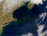
Gulf of Maine
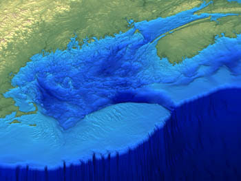
Bathymetry
Saturday, October 25, 2008
Ocean Topography
This diagram illustrates ocean topography in the Northern Hemisphere resulting from the interaction of surface wind currents and the Coriolis Effect. To learn more about ocean topography from NASA, click here. Other factors effecting ocean topography are atmospheric pressure and bathymetric features.

Rip Currents


Rip current: A strong relatively narrow current of water that flows seaward against breaking waves (physical geography.net)
"A rip current is a strong narrow channel of water that flows from the surf zone out to sea. It develops when breaking waves push onshore, then gravity pulls the water back out to sea. If the water converges into a narrow river like a channel moving away from shore, a rip current forms". ~NOAA
Birch Aquarium

The Scripps Institution of Oceanography in La Jolla, California is home to the Birch Aquarium. The mission of the Birch Aquarium is "to provide ocean science education, to interpret Scripps Institution of Oceanography research, and to promote ocean conservation." I think the link made between scientific research at the Scripps Instituion and public knowledge by the Birch Aquarium is important in understanding the local oceanic environment and its conservation. To visit the Birch Aquarium website, click here. The aquarium has important breeding programs to discourage collection of wild species, and provides a vast array of educational outreach activities such as "tidepooling with a naturalist". They are currently (end of October, Halloween) hosting a "Haunted Birch Aquarium" which looks like a lot of fun!
Oceans Arctic Expedition


This website is about an arctic expedition to the Svalbard Islands, which are located between Norway and the North Pole in the Norwegian Arctic Ocean. The expedition took place to film "surprising wildlife and natural phenomena" for the BBC Oceans series. This journey included ice diving, encounters with polar bears and giant walruses, and microscopic animals "no less exotic" than the larger mammals. The website is formatted as a travel diary, to read about these arctic adventures and to learn more about the features of this oceanic region, click here.
Tuesday, October 14, 2008
Upwelling: "Upwelling occurs when winds blowing across the ocean surface push water away from an area and subsurface water rises up to replace the diverging surface water." ~ NOAA
reference: click here
reference: click here
Oceanic Convergence & Divergence
 I thought this was a good 3-D diagram of oceanic convergence and divergence. The 'slicks' represented are naturally occurring and of biological origin. Click here to visit the Nasa source website.
WHOI Photo of the Day

This image is taken from the Woods Hole Oceanographic Institution website where they have a photo of the day feature. To visit the WHOI site, click here. These scientists are traveling in the submersible Alvin, which is unheated. As we have learned, temperature decreases with depth, which is why they are wearing hats and sweaters. These folks are diving offshore of Washington, Oregon and they are 2,660 metres below sea level.
Subscribe to:
Posts (Atom)