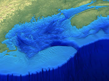
Gulf of Maine

Gulf of Maine
Bathymetry

Tuesday, December 9, 2008

We adopted a family of Right Whales!


Thanks to the kindness of the Saint Mary's University Geography community, we have symbolically adopted a family of Right Whales through the adoption program based out of the Grand Manan Whale and Seabird Research Station in New Brunswick. I will post more information about Wart and her family over the holidays. Thanks everyone!


Friday, November 28, 2008

Killing Pond Inlet narwhals 'humane harvest': DFO


I found an article on the CBC website about the narwhals trapped in Pond Inlet, Nunavut. DFO say there are no conservation issues surrounding these whales and that sustainable quotas will not be exceeded by killing the trapped whales, though more than 200 will be killed. The edge of the ice floe is too far away for the whales to get out of the unfrozen section where they are trapped. DFO doesn't want to cut a path with a ship for the whales to get out. I'm not sure what I think about this situation. It is a very complex situation and is emotionally charged for me, much like the seal hunt. Though I respect the seal hunt a lot more now as one of the more humane ways that meat is acquired in this country, I kind of think that DFO should cut a path for these whales. Population data on these whales is somewhat ambiguous. The WWF info page about narwhals can be found here.The CBC article can be found here. Photo source is here.

Sea Cucumber Feeding

I can't find a sea cucumber curled up and rolling as we discussed in class, but I found a video of one feeding.

Saturday, November 22, 2008

"Slow Progress on Ocean Protection"


This link is to a BBC article assessing the current state of ocean protection. The article concludes that less than 1% of the world's oceans are protected. The global survey was carried out by The Nature Conservancy, and the results are published in the journal Conservation Letters. Almost every country in the world signed the UN Convention on Biodiversity four years ago, which commits governments to protect 10% of the world's oceans in the interest of maintaining a healthy ecosystem. The Bijagos Archipelago, Palau, Indonesia, New Zealand, Micronesia and several Caribbean states are listed as making significant progress in marine protection. The hippos in the photo live in the coastal waters of mangrove coasts in the Bijagos Archipelago. They are clearly benefitting from the country's marine protection.

Dumbo in the Gully

This is a picture of a bizarre creature found in 'The Gully" off the coast of Nova Scotia near Sable Island. In 2007, BIO scientists explored the Gully Marine Protected area for the first time with robot submersibles. The creature in the photograph is an octopus that is approximately one metre in length. The large fins on the sides of its head look like elephant ears, which is why the nickname given to the creature by researchers is Dumbo. They belong to the cephalopod family and have been observed as deep as 7000 metres! For a fact sheet on the Dumbo octopus click here. For the article about what BIO scientists found in the gully, click here.

Monday, November 17, 2008

Real Examples


Here are real pictures of an erosional and a depositional coastline. Photocredit 1, Photocredit 2.

Erosional vs. Depostional Coastlines


I found this great diagram illustrating the differences between an erosional and a depositional coastline. Depositional coastlines are formed by the gradual building up of sediment. Erosional coastlines are obviously products of erosion. Topography, prevailing winds and ocean currents, and geology are all factors that determine the nature of a coastline. The BBC Scotland education section has a few good pages about coastlines here. Image source here.

Sunday, November 16, 2008

Environmental Propaganda


I am sorry for going on and on about Washington, but I wanted to point out these signs that I saw in the subway. After reading Carl Safina's book "Song for the Blue Ocean", it is encouraging for me to know that overfishing and subsidized overfishing is on the American radar. The websites for the organizatons responsible for these ads can be viewed here and here.

Saturday, November 15, 2008

Legal Seafoods


When I was in Washington, there was a restaurant across the street from the hotel called "Legal Sea Foods". We all thought this seemed like kind of a creepy name, wondering, legal sea food compared to what? What is illegal sea food? I don't want to know.

Upon further investigation, Legal Sea Foods is a seafood restaurant that claims to be sustainable. It has cooperated with the Marine Stewardship Council to choose what marine creatures will be on its menu. The name 'Legal Sea Food' comes from a family market that used to deal in legal food stamps in Boston in 1904 and became a fish market. The CEO of Legal Sea Food comments that they have been in business for 50 years and that they would like to be able to be in business for 50 more. There was more than one restaurant that I ran into in Washington that addressed sustainability, humanity, and care for the environment in relation to the items or creatures on its menu. This was very refreshing for me! I would like to see more of the same in Canada! Hooray Wooden Monkey. Come on Red Lobster. To read more about sustainable fisheries from National Geographic, click here. For Legal Sea Food link, click here.

Giant Squid


There was a Giant Squid in the Sant Ocean Hall that was in liquid preservative. I tried to take a picture of it but the plexiglass was covered in condensation, so the picture didn't turn out and I'll post other ones instead. Standing next to a giant squid in the Sant Ocean Hall was a good way to truly understand how giant they are.

A Giant Squid was photographed and filmed for the first time by Japanese scientists in December 2006. The creatures are elusive as they live in very deep water. Giant Squid are the world's largest invertebrate. The largest giant squid ever found was 18 metres in length and weighed 900 kg. Giant squid have the largest eyes in the animal kingdom, their eyes can be as big as a beach ball! To read more about the Giant Squid, click here.

Thursday, November 13, 2008

Wanted: a large piece of property, preferably tropical and empty, with room for 300,000 in habitants


I read an article in the Globe an Mail about rising sea level and its implications for the Maldive Islands. The Maldive Islands are low-lying coral atolls in the Indian Ocean. Mohamed Nasheed, the newly elected President of the Maldive Islands, has announced that he deems it necessary to begin an investment fund to purchase land in anticipation of the likely relocation of the country's 300,000 inhabitants due to global sea-level rise and human induced climate change.

The President has made his predicament clear: "The Maldives have no other option but to find themselves another piece of land somewhere," he said. "This decision comes from the President's understanding that the political will to save them doesn't exist." He reasons that "We do not want to leave the Maldives, but we also do not want to be climate refugees living in tents for decades." To read the full article, click here.

Western Boundary Current


"A western boundary current is a warm, deep, narrow, and fast flowing current that occurs on the west side of an ocean basin. They are important in climate control by bringing warm water from the equator northward. Its narrowness results from the displacement of the geostrophic 'hill' to the western side of ocean basins due to the Coriolis effect, compressing the currents on this side" (reference).
For diagram source click here.

Spotted Eagle Ray


These pictures are of a creature called the spotted eagle ray. As we are heading into the biological component of this course, this is one example of the most bizarre looking (and beautiful all at the same time) sea creatures that I know of. This ray has an equatorial and low latitude habitat range, swims many miles within schools in the open ocean, and also swims in bays over coral reefs or into estuaries. The eagle ray has a diet that includes clams, oysters, shrimp, octopus, squid, sea urchins, and bony fishes. To learn more about this interesting creature, click here.

Beebe, Barton, and the Bathysphere


The original Bathysphere is now at the New York Aquarium at Coney Island. This photograph I took at the National Geographic Society in Washington. This is a fibreglass model of the original. The word bathysphere, referring to a spherical deep sea submersible, comes from the Greek word bathos meaning depth and sphaira meaning sphere (reference).

The original Bathysphere was built by two adventurous explorers named William Beebe and Otis Barton with support from the New York Zoological Society and the National Geographic Society. For the first time in 1932, Beebe and Barton descended 2,200 feet under the ocean
in the Bathysphere off the coast of Bermuda. This was deeper than any Naval submarine had ever explored. In 1934 they successfully descended to 3,027 feet. The explorers were able to describe the mysterious and wonderful underwater world to the public for the first time, as they peered through the quartz windows of their craft. To read more about Beebe's and Barton's daring underwater adventures, click here.

Sunday, November 2, 2008

Tsunamis


Tsunami: (seismic sea wave) long-period sea wave produced by a submarine earthquake, volcanic eruption, sediment slide, or seafloor faulting. It may travel across the ocean for thousands of miles unnoticed from its point of origin and build up to great heights over shallow water at the shore.

Source: An Introduction to the World's Oceans glossary


Diagram Source: New Zealand Government Tsunami info page

Ocean Eddies


An eddy is defined by our textbook as the circular movement of water. The following quote from the textbook describes the process that forms an eddy: "When a narrow, fast-moving current moves into or through slower-moving water, the force of its flow displaces the quieter water and captures additional water as it does so. The current oscillates and develops waves along its boundary that are known as meanders. These meanders break off to form eddies, or pockets of water moving with a circular motion; eddies take with them energy of motion from the main flow and gradually dissipate this energy through friction." Click here to learn more about eddies.

Deep Ocean Circulation in the Atlantic Ocean


Here is an interesting diagram of the deep ocean circulation pattern in the Atlantic Ocean. Factors effecting this pattern are: temperature, salinity, density, rainfall, evaporation, bathymetry, freezing, and thawing. For an in-depth analysis of this diagram, click here.

More Bathymetry


Here's a really cool bathymetric map of the entire North Atlantic. This map is generated by NOAA, but I found it on the Northwest Atlantic Fisheries Organization (NAFO) website, to visit the site click here.

Saturday, October 25, 2008

Ocean Topography

This diagram illustrates ocean topography in the Northern Hemisphere resulting from the interaction of surface wind currents and the Coriolis Effect. To learn more about ocean topography from NASA, click here. Other factors effecting ocean topography are atmospheric pressure and bathymetric features.

Rip Currents


Rip current: A strong relatively narrow current of water that flows seaward against breaking waves (physical geography.net)

"A rip current is a strong narrow channel of water that flows from the surf zone out to sea. It develops when breaking waves push onshore, then gravity pulls the water back out to sea. If the water converges into a narrow river like a channel moving away from shore, a rip current forms".
~NOAA

Birch Aquarium


The Scripps Institution of Oceanography in La Jolla, California is home to the Birch Aquarium. The mission of the Birch Aquarium is "to provide ocean science education, to interpret Scripps Institution of Oceanography research, and to promote ocean conservation." I think the link made between scientific research at the Scripps Instituion and public knowledge by the Birch Aquarium is important in understanding the local oceanic environment and its conservation. To visit the Birch Aquarium website, click here. The aquarium has important breeding programs to discourage collection of wild species, and provides a vast array of educational outreach activities such as "tidepooling with a naturalist". They are currently (end of October, Halloween) hosting a "Haunted Birch Aquarium" which looks like a lot of fun!

Oceans Arctic Expedition


This website is about an arctic expedition to the Svalbard Islands, which are located between Norway and the North Pole in the Norwegian Arctic Ocean. The expedition took place to film "surprising wildlife and natural phenomena" for the BBC Oceans series. This journey included ice diving, encounters with polar bears and giant walruses, and microscopic animals "no less exotic" than the larger mammals. The website is formatted as a travel diary, to read about these arctic adventures and to learn more about the features of this oceanic region, click here.

Tuesday, October 14, 2008

Upwelling: "Upwelling occurs when winds blowing across the ocean surface push water away from an area and subsurface water rises up to replace the diverging surface water." ~ NOAA

reference: click here

Oceanic Convergence & Divergence

I thought this was a good 3-D diagram of oceanic convergence and divergence. The 'slicks' represented are naturally occurring and of biological origin. Click here to visit the Nasa source website.

WHOI Photo of the Day


This image is taken from the Woods Hole Oceanographic Institution website where they have a photo of the day feature. To visit the WHOI site, click here. These scientists are traveling in the submersible Alvin, which is unheated. As we have learned, temperature decreases with depth, which is why they are wearing hats and sweaters. These folks are diving offshore of Washington, Oregon and they are 2,660 metres below sea level.

Sunday, October 5, 2008

Visible Gyre East of Japan


Nasa's Visible Earth has really great satellite images

South Pacific Bare Zone


Oceanographers have discovered a patch of seafloor in the Southern Pacific Ocean that is almost devoid of oceanic sediments. To read the full article in Science News click here.

While most of the seafloor's basaltic oceanic crust is typically covered with a sediment layer hundreds of metres in thickness, "an unusual combination of circumstances" has left 2 million square kilometres of seafloor devoid of this sedimentary layer of organic and mineral sediments.

The reasons given for this patch of naked ocean floor are:

~ Regional waters are nutrient poor. Therefore, few organisms live here or are present to die, fall to the seafloor, and create biogenous sediment.

~ "The deepest waters in this area contain less carbonate and silica than other locations do, so skeletons of organisms that reach the seafloor dissolve."

~This region is distant from any landmass, and therefore has no source of windblown sediments that would settle on the bottom to create lithogenous sediment.

~ Little or no regional hydrothermal activity to produce dissolved minerals that would precipitate into volcanogenic sediment.

This lack of ocean sediment may allow researchers to study seafloor features that would otherwise be hidden, such as meteor dust.