Here's a really cool bathymetric map of the entire North Atlantic. This map is generated by NOAA, but I found it on the Northwest Atlantic Fisheries Organization (NAFO) website, to visit the site click here.
The dark blue areas represent primary regions of upwelling. Click on the map to visit the UN Ocean Atlas source website.
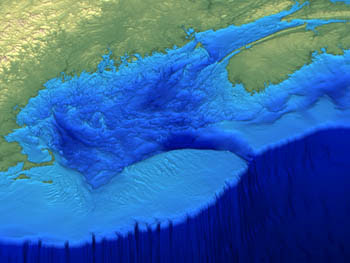
Underwater Landslide
This is the type of underwater landslide that can generate a tsunami. The diagram is by Zeke Smith, click on the picture to visit the website. It is from an article in a California science magazine discussing tsunami hazards.


No comments:
Post a Comment